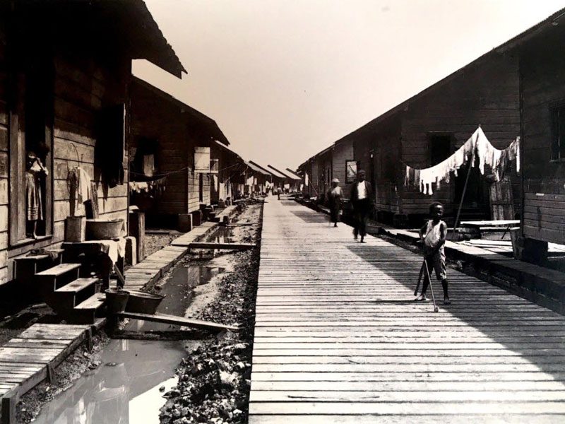
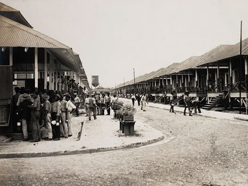
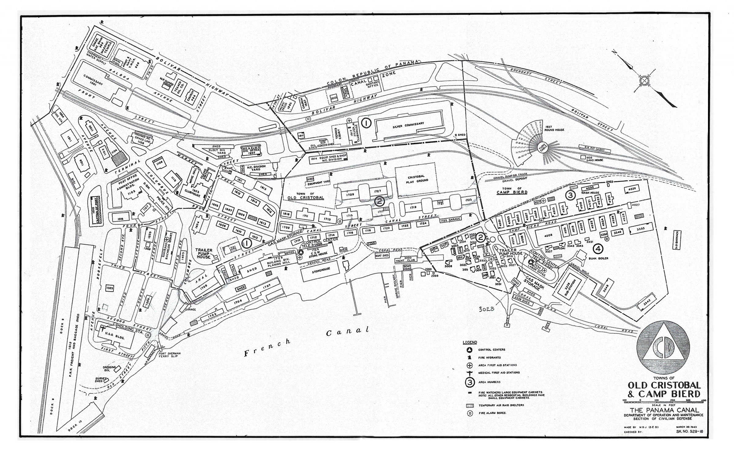
Canal Zone
Town of Old Cristobal And Camp Bierd
History
In the 1880s, the French Inter-Oceanic Canal Company arrived to find the port of Colón (then Aspinwall) just a few streets wide and long while the rest of Manzanillo Island was still a swamp. They used soil from their canal excavation works to create a landfill on a coral reef adjacent to the Panama Railroad’s area of Colon. This new landfill area, upon which the French built their facilities, was called Christophe Colombe, a name which was translated in Spanish as Cristóbal Colón.
The mid-1950s saw the greatest transformation of Cristobal. This change saw a drastic population shift of Cristobalites to new areas in Margarita and Coco Solo, and the redefinition of territorial boundaries which reduced the extension of the Canal Zone on Manzanillo Island. These changes came about as a result of the construction of the town of Margarita, the 1955 bilateral treaty, and the US Navy’s transfer of its Coco Solo Station to the Canal Zone government. Cristóbal’s population in 1955 dropped to 562, and New Cristóbal’s to 1,130.
0
Apartment buildings
0
Families
0
1950 - 1960 Census Population
Town of Old Cristobal And Camp Bierd Interactive map
Click on the building number icons to view house residents.
BUILDING 1716
Town of Old Cristobal And Camp Bierd
- Building Type: Army Quarters
- Building Desc: 10-Unit Bachelor Quarters
- Number of occupants in the building: 1
- Number of rooms in each apartment: N/A
BUILDING 1714
Town of Old Cristobal And Camp Bierd
- Building Type: Army Quarters
- Building Desc: 10-Unit Bachelor Quarters
- Number of occupants in the building: 1
- Number of rooms in each apartment: N/A
BUILDING 1712
Town of Old Cristobal And Camp Bierd
- Building Type: Army Quarters
- Building Desc: 10-Unit Bachelor Quarters
- Number of occupants in the building: 1
- Number of rooms in each apartment: N/A
BUILDING 1710
Town of Old Cristobal And Camp Bierd
- Building Type: Army Quarters
- Building Desc: 10-Unit Bachelor Quarters
- Number of occupants in the building: 3
- Number of rooms in each apartment: N/A
BUILDING 1713
Town of Old Cristobal And Camp Bierd
- Building Type: Army Quarters
- Building Desc: 10-Unit Bachelor Quarters
- Number of occupants in the building: 1
- Number of rooms in each apartment: N/A
BUILDING 1715
Town of Old Cristobal And Camp Bierd
- Building Type: Army Quarters
- Building Desc: 10-Unit Bachelor Quarters
- Number of occupants in the building: 1
- Number of rooms in each apartment: N/A
BUILDING 1711
Town of Old Cristobal And Camp Bierd
- Building Type: Army Quarters
- Building Desc: 10-Unit Bachelor Quarters
- Number of occupants in the building: 1
- Number of rooms in each apartment: N/A
BUILDING 1709
Town of Old Cristobal And Camp Bierd
- Building Type: Army Quarters
- Building Desc: 10-Unit Bachelor Quarters
- Number of occupants in the building: 1
- Number of rooms in each apartment: N/A
BUILDING 1701
Town of Old Cristobal And Camp Bierd
- Building Type: Army Quarters
- Building Desc: 10-Unit Bachelor Quarters
- Number of occupants in the building: 1
- Number of rooms in each apartment: N/A
BUILDING 1613
Town of Old Cristobal And Camp Bierd
- Building Type: Army Quarters
- Building Desc: Bachelor Quarters
- Number of occupants in the building: 1
- Number of rooms in each apartment: N/A
BUILDING 1609
Town of Old Cristobal And Camp Bierd
- Building Type: Army Quarters
- Building Desc: Bachelor Quarters
- Number of occupants in the building: 1
- Number of rooms in each apartment: N/A
BUILDING 1607
Town of Old Cristobal And Camp Bierd
- Building Type: Army Quarters
- Building Desc: Bachelor Quarters
- Number of occupants in the building: 1
- Number of rooms in each apartment: N/A
BUILDING 1605
Town of Old Cristobal And Camp Bierd
- Building Type: Army Quarters
- Building Desc: Bachelor Quarters
- Number of occupants in the building: 1
- Number of rooms in each apartment: N/A
BUILDING 1812
Town of Old Cristobal And Camp Bierd
- Building Type: Army Quarters
- Building Desc: Bachelor Quarters
- Number of occupants in the building: 1
- Number of rooms in each apartment: N/A
BUILDING 1811
Town of Old Cristobal And Camp Bierd
- Building Type: Army Quarters
- Building Desc: Bachelor Quarters
- Number of occupants in the building: 1
- Number of rooms in each apartment: N/A
BUILDING 1814
Town of Old Cristobal And Camp Bierd
- Building Type: Army Quarters
- Building Desc: Bachelor Quarters
- Number of occupants in the building: 1
- Number of rooms in each apartment: N/A
BUILDING 1813
Town of Old Cristobal And Camp Bierd
- Building Type: Army Quarters
- Building Desc: 10-Unit Bachelor Quarters
- Number of occupants in the building: 17
- Number of rooms in each apartment: N/A
BUILDING 1816
Town of Old Cristobal And Camp Bierd
- Building Type: Army Quarters
- Building Desc: Bachelor Quarters
- Number of occupants in the building: 1
- Number of rooms in each apartment: N/A
BUILDING 1997
Town of Old Cristobal And Camp Bierd
- Building Type: Church
- Building Desc: Church
- Number of occupants in the building: N/A
- Number of rooms in each apartment: N/A
BUILDING 2005
Town of Old Cristobal And Camp Bierd
- Building Type: Church
- Building Desc: Salvation Army
- Number of occupants in the building: N/A
- Number of rooms in each apartment: N/A
BUILDING 1995
Town of Old Cristobal And Camp Bierd
- Building Type: Office
- Building Desc: Pacific Press Quarters
- Number of occupants in the building: N/A
- Number of rooms in each apartment: N/A
BUILDING 996
Town of Old Cristobal And Camp Bierd
- Building Type: Church
- Building Desc: Church Quarters
- Number of occupants in the building: N/A
- Number of rooms in each apartment: N/A
BUILDING 1001
Town of Old Cristobal And Camp Bierd
- Building Type: Commissary
- Building Desc: Commissary Quarters
- Number of occupants in the building: N/A
- Number of rooms in each apartment: N/A
BUILDING 1604
Town of Old Cristobal And Camp Bierd
- Building Type: Army Quarters
- Building Desc: Bachelor Quarters
- Number of occupants in the building: 1
- Number of rooms in each apartment: N/A
BUILDING 1105
Town of Old Cristobal And Camp Bierd
- Building Type: Office
- Building Desc: Post Office
- Number of occupants in the building: N/A
- Number of rooms in each apartment: N/A
BUILDING 1004
Town of Old Cristobal And Camp Bierd
- Building Type: Office
- Building Desc: Firehouse
- Number of occupants in the building: N/A
- Number of rooms in each apartment: N/A
BUILDING 1612
Town of Old Cristobal And Camp Bierd
- Building Type: Army Quarters
- Building Desc: 10-Unit Bachelor Quarters
- Number of occupants in the building: 1
- Number of rooms in each apartment: N/A
BUILDING 1610
Town of Old Cristobal And Camp Bierd
- Building Type: Army Quarters
- Building Desc: 10-Unit Bachelor Quarters
- Number of occupants in the building: 1
- Number of rooms in each apartment: N/A
BUILDING 1608
Town of Old Cristobal And Camp Bierd
- Building Type: Army Quarters
- Building Desc: 10-Unit Bachelor Quarters
- Number of occupants in the building: 1
- Number of rooms in each apartment: N/A
BUILDING 1717
Town of Old Cristobal And Camp Bierd
- Building Type: Army Quarters
- Building Desc: 10-Unit Bachelor Quarters
- Number of occupants in the building: 9
- Number of rooms in each apartment: N/A
BUILDING 1719
Town of Old Cristobal And Camp Bierd
- Building Type: Army Quarters
- Building Desc: 10-Unit Bachelor Quarters
- Number of occupants in the building: 11
- Number of rooms in each apartment: N/A
BUILDING 1721
Town of Old Cristobal And Camp Bierd
- Building Type: Army Quarters
- Building Desc: 10-Unit Bachelor Quarters
- Number of occupants in the building: 10
- Number of rooms in each apartment: N/A
BUILDING 1723
Town of Old Cristobal And Camp Bierd
- Building Type: Army Quarters
- Building Desc: 10-Unit Bachelor Quarters
- Number of occupants in the building: 10
- Number of rooms in each apartment: N/A
BUILDING 1727
Town of Old Cristobal And Camp Bierd
- Building Type: Army Quarters
- Building Desc: 10-Unit Bachelor Quarters
- Number of occupants in the building: 12
- Number of rooms in each apartment: N/A
BUILDING 1729
Town of Old Cristobal And Camp Bierd
- Building Type: Army Quarters
- Building Desc: 10-Unit Bachelor Quarters
- Number of occupants in the building: 9
- Number of rooms in each apartment: N/A
BUILDING 1917
Town of Old Cristobal And Camp Bierd
- Building Type: Recreational
- Building Desc: Silver Clubhouse
- Number of occupants in the building: N/A
- Number of rooms in each apartment: N/A
BUILDING 1718
Town of Old Cristobal And Camp Bierd
- Building Type: Army Quarters
- Building Desc: 10-Unit Bachelor Quarters
- Number of occupants in the building: 1
- Number of rooms in each apartment: N/A
BUILDING 1720
Town of Old Cristobal And Camp Bierd
- Building Type: Army Quarters
- Building Desc: 10-Unit Bachelor Quarters
- Number of occupants in the building: 1
- Number of rooms in each apartment: N/A
BUILDING 1722
Town of Old Cristobal And Camp Bierd
- Building Type: Army Quarters
- Building Desc: 10-Unit Bachelor Quarters
- Number of occupants in the building: 1
- Number of rooms in each apartment: N/A
BUILDING 1724
Town of Old Cristobal And Camp Bierd
- Building Type: Army Quarters
- Building Desc: 10-Unit Bachelor Quarters
- Number of occupants in the building: 1
- Number of rooms in each apartment: N/A
BUILDING 3003
Town of Old Cristobal And Camp Bierd
- Building Type: Army Quarters
- Building Desc: 1-Unit Family Bldg
- Number of occupants in the building: 3
- Number of rooms in each apartment: 3
BUILDING 3004
Town of Old Cristobal And Camp Bierd
- Building Type: Army Quarters
- Building Desc: 1-Unit Family Bldg
- Number of occupants in the building: 8
- Number of rooms in each apartment: 4
BUILDING 3005
Town of Old Cristobal And Camp Bierd
- Building Type: Army Quarters
- Building Desc: 1-Unit Family Bldg
- Number of occupants in the building: 5
- Number of rooms in each apartment: 5
BUILDING 3008
Town of Old Cristobal And Camp Bierd
- Building Type: Army Quarters
- Building Desc: 1-Unit Family Bldg
- Number of occupants in the building: 4
- Number of rooms in each apartment: 8
BUILDING 3009
Town of Old Cristobal And Camp Bierd
- Building Type: Army Quarters
- Building Desc: 1-Unit Family Bldg
- Number of occupants in the building: 3
- Number of rooms in each apartment: 4
BUILDING 3015
Town of Old Cristobal And Camp Bierd
- Building Type: Army Quarters
- Building Desc: 1-Unit Family Bldg
- Number of occupants in the building: 3
- Number of rooms in each apartment: 3
BUILDING 3006
Town of Old Cristobal And Camp Bierd
- Building Type: Army Quarters
- Building Desc: 2-Unit Family Bldg
- Number of occupants in the building: 8
- Number of rooms in each apartment: 3
BUILDING 3007
Town of Old Cristobal And Camp Bierd
- Building Type: Army Quarters
- Building Desc: 2-Unit Family Bldg
- Number of occupants in the building: 5
- Number of rooms in each apartment: 2
BUILDING 3012
Town of Old Cristobal And Camp Bierd
- Building Type: Army Quarters
- Building Desc: 1-Unit Family Bldg
- Number of occupants in the building: 4
- Number of rooms in each apartment: 3
BUILDING 3012
Town of Old Cristobal And Camp Bierd
- Building Type: Army Quarters
- Building Desc: 1-Unit Family Bldg
- Number of occupants in the building: 4
- Number of rooms in each apartment: 3
BUILDING 3016
Town of Old Cristobal And Camp Bierd
- Building Type: Industrial
- Building Desc: Trailer Pump House
- Number of occupants in the building: 2
- Number of rooms in each apartment: 3
BUILDING 3031
Town of Old Cristobal And Camp Bierd
- Building Type: Army Quarters
- Building Desc: 1-Unit Family Bldg
- Number of occupants in the building: 7
- Number of rooms in each apartment: 2
BUILDING 3334
Town of Old Cristobal And Camp Bierd
- Building Type: Office
- Building Desc: Labor Office
- Number of occupants in the building: N/A
- Number of rooms in each apartment: N/A
BUILDING 3338
Town of Old Cristobal And Camp Bierd
- Building Type: Industrial
- Building Desc: Storage Shed
- Number of occupants in the building: N/A
- Number of rooms in each apartment: N/A
BUILDING 3339
Town of Old Cristobal And Camp Bierd
- Building Type: Industrial
- Building Desc: Sub-Station
- Number of occupants in the building: 27
- Number of rooms in each apartment: N/A
BUILDING 3335
Town of Old Cristobal And Camp Bierd
- Building Type: Army Quarters
- Building Desc: 1-Unit Family Bldg
- Number of occupants in the building: N/A
- Number of rooms in each apartment: 2
BUILDING 3018
Town of Old Cristobal And Camp Bierd
- Building Type: Army Quarters
- Building Desc: 1-Unit Family Bldg
- Number of occupants in the building: 4
- Number of rooms in each apartment: 3
BUILDING 3019
Town of Old Cristobal And Camp Bierd
- Building Type: Army Quarters
- Building Desc: 1-Unit Family Bldg
- Number of occupants in the building: 6
- Number of rooms in each apartment: 3
BUILDING 3021
Town of Old Cristobal And Camp Bierd
- Building Type: Army Quarters
- Building Desc: 1-Unit Family Bldg
- Number of occupants in the building: 9
- Number of rooms in each apartment: 3
BUILDING 3022
Town of Old Cristobal And Camp Bierd
- Building Type: Army Quarters
- Building Desc: 1-Unit Family Bldg
- Number of occupants in the building: 1
- Number of rooms in each apartment: 3
BUILDING 3023
Town of Old Cristobal And Camp Bierd
- Building Type: Army Quarters
- Building Desc: 1-Unit Family Bldg
- Number of occupants in the building: 3
- Number of rooms in each apartment: 3
BUILDING 3333
Town of Old Cristobal And Camp Bierd
- Building Type: Army Quarters
- Building Desc: 1-Unit Family Bldg
- Number of occupants in the building: 3
- Number of rooms in each apartment: 2
BUILDING 3025
Town of Old Cristobal And Camp Bierd
- Building Type: Army Quarters
- Building Desc: 1-Unit Family Bldg
- Number of occupants in the building: 2
- Number of rooms in each apartment: 2
BUILDING 3027
Town of Old Cristobal And Camp Bierd
- Building Type: Army Quarters
- Building Desc: 1-Unit Family Bldg
- Number of occupants in the building: 2
- Number of rooms in each apartment: 2
BUILDING 3337
Town of Old Cristobal And Camp Bierd
- Building Type: Army Quarters
- Building Desc: 1-Unit Family Bldg
- Number of occupants in the building: 11
- Number of rooms in each apartment: 3
BUILDING 4004
Town of Old Cristobal And Camp Bierd
- Building Type: Army Quarters
- Building Desc: Unknown
- Number of occupants in the building: Vacant Unit
- Number of rooms in each apartment: Unknown
BUILDING 4005
Town of Old Cristobal And Camp Bierd
- Building Type: Army Quarters
- Building Desc: Unknown
- Number of occupants in the building: Vacant Unit
- Number of rooms in each apartment: Unknown
BUILDING 4016
Town of Old Cristobal And Camp Bierd
- Building Type: Army Quarters
- Building Desc: Unknown
- Number of occupants in the building: Vacant Unit
- Number of rooms in each apartment: Unknown
BUILDING 4018
Town of Old Cristobal And Camp Bierd
- Building Type: Army Quarters
- Building Desc: Census-No Data
- Number of occupants in the building: Vacant Unit
- Number of rooms in each apartment: Census-No Data
BUILDING 4020
Town of Old Cristobal And Camp Bierd
- Building Type: Army Quarters
- Building Desc: Census-No Data
- Number of occupants in the building: Vacant Unit
- Number of rooms in each apartment: Census-No Data
BUILDING 4022
Town of Old Cristobal And Camp Bierd
- Building Type: Army Quarters
- Building Desc: Census-No Data
- Number of occupants in the building: Vacant Unit
- Number of rooms in each apartment: Census-No Data
BUILDING 4024
Town of Old Cristobal And Camp Bierd
- Building Type: Army Quarters
- Building Desc: Census-No Data
- Number of occupants in the building: Vacant Unit
- Number of rooms in each apartment: Census-No Data
BUILDING 4026
Town of Old Cristobal And Camp Bierd
- Building Type: Army Quarters
- Building Desc: Census-No Data
- Number of occupants in the building: Vacant Unit
- Number of rooms in each apartment: Census-No Data
BUILDING 4028
Town of Old Cristobal And Camp Bierd
- Building Type: Army Quarters
- Building Desc: Census-No Data
- Number of occupants in the building: Vacant Unit
- Number of rooms in each apartment: Census-No Data
BUILDING 4027
Town of Old Cristobal And Camp Bierd
- Building Type: Army Quarters
- Building Desc: Census-No Data
- Number of occupants in the building: Vacant Unit
- Number of rooms in each apartment: Census-No Data
BUILDING 4029
Town of Old Cristobal And Camp Bierd
- Building Type: Army Quarters
- Building Desc: Census-No Data
- Number of occupants in the building: Vacant Unit
- Number of rooms in each apartment: Census-No Data
BUILDING 4030
Town of Old Cristobal And Camp Bierd
- Building Type: Army Quarters
- Building Desc: Census-No Data
- Number of occupants in the building: Vacant Unit
- Number of rooms in each apartment: Census-No Data
BUILDING 4008
Town of Old Cristobal And Camp Bierd
- Building Type: Army Quarters
- Building Desc: Unknown
- Number of occupants in the building: Vacant Unit
- Number of rooms in each apartment: Unknown
BUILDING 4001
Town of Old Cristobal And Camp Bierd
- Building Type: Army Quarters
- Building Desc: 7-Unit Bachelor Bldg
- Number of occupants in the building: 13
- Number of rooms in each apartment: 1
BUILDING 4003
Town of Old Cristobal And Camp Bierd
- Building Type: Army Quarters
- Building Desc: 5-Unit Family Bldg
- Number of occupants in the building: 12
- Number of rooms in each apartment: 1
BUILDING 4005
Town of Old Cristobal And Camp Bierd
- Building Type: Army Quarters
- Building Desc: 5-Unit Family Bldg
- Number of occupants in the building: 22
- Number of rooms in each apartment: 1
BUILDING 4007
Town of Old Cristobal And Camp Bierd
- Building Type: Army Quarters
- Building Desc: 5-Unit Family Bldg
- Number of occupants in the building: 16
- Number of rooms in each apartment: 1
BUILDING 4009
Town of Old Cristobal And Camp Bierd
- Building Type: Army Quarters
- Building Desc: 5-Unit Family Bldg
- Number of occupants in the building: 30
- Number of rooms in each apartment: 1
BUILDING 4011
Town of Old Cristobal And Camp Bierd
- Building Type: Army Quarters
- Building Desc: 5-Unit Family Bldg
- Number of occupants in the building: 17
- Number of rooms in each apartment: 1
BUILDING 4013
Town of Old Cristobal And Camp Bierd
- Building Type: Army Quarters
- Building Desc: 5-Unit Family Bldg
- Number of occupants in the building: 16
- Number of rooms in each apartment: 1
BUILDING 4015
Town of Old Cristobal And Camp Bierd
- Building Type: Army Quarters
- Building Desc: 5-Unit Family Bldg
- Number of occupants in the building: 11
- Number of rooms in each apartment: 1
BUILDING 4019
Town of Old Cristobal And Camp Bierd
- Building Type: Army Quarters
- Building Desc: 5-Unit Family Bldg
- Number of occupants in the building: 19
- Number of rooms in each apartment: 1
BUILDING 4021
Town of Old Cristobal And Camp Bierd
- Building Type: Army Quarters
- Building Desc: 5-Unit Family Bldg
- Number of occupants in the building: 18
- Number of rooms in each apartment: 1
BUILDING 4023
Town of Old Cristobal And Camp Bierd
- Building Type: Army Quarters
- Building Desc: 5-Unit Family Bldg
- Number of occupants in the building: 19
- Number of rooms in each apartment: 1
BUILDING 4025
Town of Old Cristobal And Camp Bierd
- Building Type: Army Quarters
- Building Desc: 5-Unit Family Bldg
- Number of occupants in the building: 22
- Number of rooms in each apartment: 1
BUILDING 3341
Town of Old Cristobal And Camp Bierd
- Building Type: Army Quarters
- Building Desc: 1-Unit Family Bldg
- Number of occupants in the building: 8
- Number of rooms in each apartment: 3
BUILDING 3343
Town of Old Cristobal And Camp Bierd
- Building Type: Army Quarters
- Building Desc: 1-Unit Family Bldg
- Number of occupants in the building: Vacant Unit
- Number of rooms in each apartment: N/A
BUILDING 3349
Town of Old Cristobal And Camp Bierd
- Building Type: Army Quarters
- Building Desc: 75-Unit Bachelor Dorm
- Number of occupants in the building: 26
- Number of rooms in each apartment: N/A
BUILDING 3348
Town of Old Cristobal And Camp Bierd
- Building Type: Army Quarters
- Building Desc: 75-Unit Bachelor Dorm
- Number of occupants in the building: 54
- Number of rooms in each apartment: N/A
BUILDING 3353
Town of Old Cristobal And Camp Bierd
- Building Type: Army Quarters
- Building Desc: 16-Unit Bachelor Dorm
- Number of occupants in the building: 87
- Number of rooms in each apartment: N/A
BUILDING 3351
Town of Old Cristobal And Camp Bierd
- Building Type: Army Quarters
- Building Desc: 1-Unit Family Bldg
- Number of occupants in the building: Vacant Unit
- Number of rooms in each apartment: N/A
BUILDING 3352
Town of Old Cristobal And Camp Bierd
- Building Type: Army Quarters
- Building Desc: 1- Unit Family Bldg
- Number of occupants in the building: Vacant Unit
- Number of rooms in each apartment: N/A
BUILDING 3024
Town of Old Cristobal And Camp Bierd
- Building Type: Army Quarters
- Building Desc: 1- Unit Family Bldg
- Number of occupants in the building: 3
- Number of rooms in each apartment: 3
BUILDING 3024
Town of Old Cristobal And Camp Bierd
- Building Type: Army Quarters
- Building Desc: 1- Unit Family Bldg
- Number of occupants in the building: 13
- Number of rooms in each apartment: 2
BUILDING 3013
Town of Old Cristobal And Camp Bierd
- Building Type: Army Quarters
- Building Desc: 1-Unit Family Bldg
- Number of occupants in the building: 1
- Number of rooms in each apartment: 2
BUILDING 1725
Town of Old Cristobal And Camp Bierd
- Building Type: Industrial
- Building Desc: Garage
- Number of occupants in the building: N/A
- Number of rooms in each apartment: N/A
BUILDING 1939
Town of Old Cristobal And Camp Bierd
- Building Type: Industrial
- Building Desc: Sand House
- Number of occupants in the building: N/A
- Number of rooms in each apartment: N/A
BUILDING 1937
Town of Old Cristobal And Camp Bierd
- Building Type: Industrial
- Building Desc: PRR - Round House
- Number of occupants in the building: N/A
- Number of rooms in each apartment: N/A
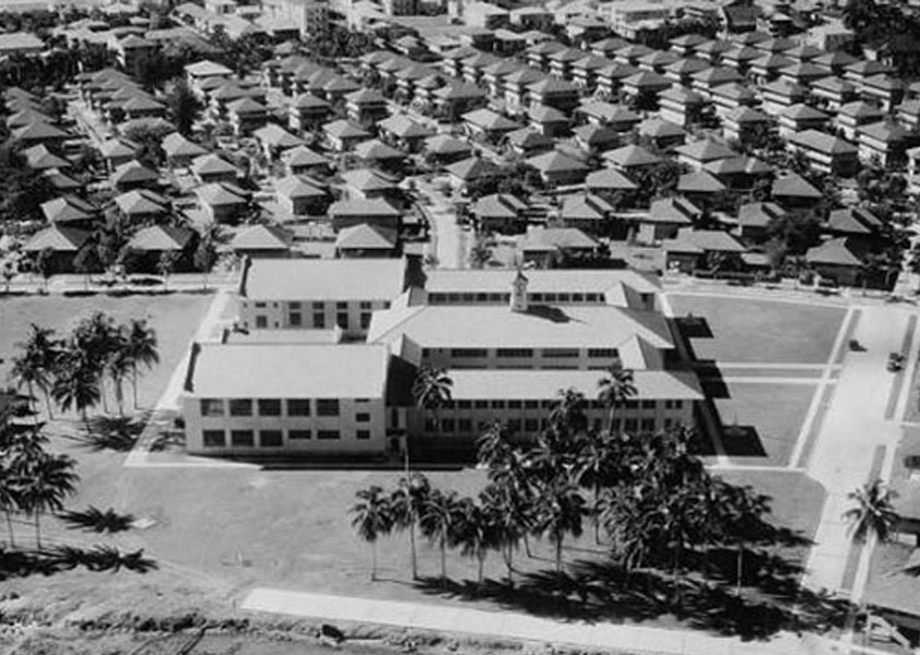
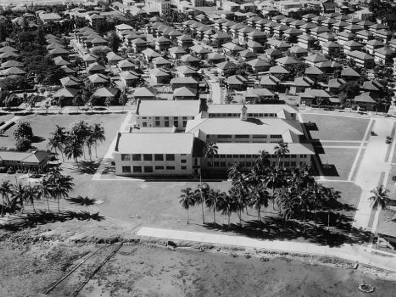
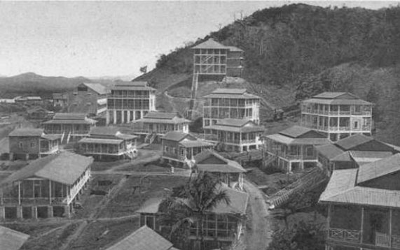
TOWN OF OLD CRISTOBAL AND CAMP BIERD Aerial View
View from the Cristobal High School.
AFRO-PANAMA
Canal Zone Legacy Project
- Building Type: Army Quarters
- Building Desc: Single Men Quarters
- Serial# of Dwelling Unit: Room# N/A
- Monthly Unit Rent: N/A
- Unit Town Section: Old Paraiso
- Unit Occupants First Name: Frederick S.
- Unit Occupant Last Name: Hibbert
- Relationship: Not Listed
- Age: 59
- Race: Negro
- Occupant Work: Mech Helper
- Occupant Business: M.E. Div
- Job Code: 6903782
AFRO-PANAMA
Canal Zone Legacy Project
- Building Type: Army Quarters
- Building Desc: Single Men Quarters
- Serial# of Dwelling Unit: Room# N/A
- Monthly Unit Rent: N/A
- Unit Town Section: Old Paraiso
- Unit Occupants First Name: Eric L.
- Unit Occupant Last Name: Stevens
- Relationship: Not Listed
- Age: 22
- Race: Negro
- Occupant Work: Carpenter Helper
- Occupant Business: Building Div
- Job Code: 9702462
AFRO-PANAMA
Canal Zone Legacy Project
- Building Type: Army Quarters
- Building Desc: Single Men Quarters
- Serial# of Dwelling Unit: Room# N/A
- Monthly Unit Rent: N/A
- Unit Town Section: Old Paraiso
- Unit Occupants First Name: Loreno
- Unit Occupant Last Name: Joseph
- Relationship: Not Listed
- Age: 23
- Race: Negro
- Occupant Work: Attendant
- Occupant Business: Health Dept
- Job Code: 7308682